Latest News
- Mitigation Of Disaster Risk Bid
- Robot Begins Operations At Al-Zour Refinery
- Woman Gets 5 Years Jail For Assaulting An Old Lady
- Kuwaiti Suffered A Cardiac Arrest In A 7-vehicle Collision
- Accused Kuwait Police Officers Arrested Over Teen Abuse Scandal
- Egyptian Gets 7 Years For KD29,000 Kuwait Towers Ticket Fraud
- Kuwait Revises Overseas Recruitment
- 22,897 Kuwaiti Citizens And Expats Are Banned From Traveling
- Kuwait Is An Emerging Tourism Powerhouse
- A Total Of 41 Centers Will Provide Vaccinations And Hajj Instruc...
- New Employer File Opening Service Launched By PAM Via Sahel Busi...
- Issuing Work Permits Based On Academic Certificates And Experien...
India Launches Own Gps Satellite
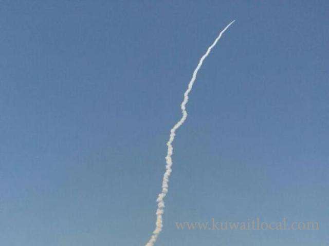
A regional navigation satellite system with just seven spacecraft and in civil domain is unique to India.
ISRO's PSLV-C33, carrying India's seventh navigation satellite IRNSS-1G, blasted off from the Satish Dhawan Space Centre in Sriharikota at 12.50 p.m.on Thursday. The satellite was successfully placed in sub-Geosynchronous Transfer Orbit.
The countdown for the launch of the 1,425-kg satellite began at 9.20 a.m. on Tuesday. The integration of the rocket on the launch pad and the propellant filling operations were taken up at different stages during the 51.30-hour countdown.
A regional navigation satellite system with just seven spacecraft and in civil domain is unique to India. The three global versions of other countries offer worldwide commercial coverage and are operated by their militaries.
IRNSS (Indian Regional Navigation Satellite System) will be to the subcontinent what the GPS is to its users worldwide, but with far greater precision and in Indian control, according to the Indian Space Research Organisation. It is expected to provide position accuracy of better than 20 m over Indian region and also an area extending up to 1,500 sq. km around India.
The well-known GPS is owned by the U.S. Air Force; Russia has GLONASS and China is expanding its regional BeiDou into a global system, also operated by its military. Europe’s GALILEO is a civil global system. They each have between 28 and 35 satellites.
IRNSS will drive both everyday uses as a 24/7 standard service for air, sea, ship transport among others. It will also be used for military and missile-related applications as an encrypted and restricted service.
Over the next three to six months, all the IRNSS satellites would be stabilised as a constellation, their signals and performance verified and later put to use, an ISRO official said.
Two spare satellites are kept ready to be flown in an emergency. A full-fledged ground control centre in Bengaluru and tracking stations across the country have been put in place.
The constellation has been in the making since July 2013, when IRNSS-1A, was launched. ISRO placedIRNSS-1E and IRNSS-1F in January and March this year, each with a designed life of 12 years.
They are identical, with each carrying a navigation payload and a ranging payload in different bands, according to ISRO.
SOURCE : THEHINDU

Related News

-
 Mitigation Of Disaster Risk Bid
07 May 2024
Mitigation Of Disaster Risk Bid
07 May 2024 -
 Robot Begins Operations At Al-Zour Refinery
07 May 2024
Robot Begins Operations At Al-Zour Refinery
07 May 2024 -
 Kuwait Revises Overseas Recruitment
07 May 2024
Kuwait Revises Overseas Recruitment
07 May 2024 -
 Kuwait Is An Emerging Tourism Powerhouse
07 May 2024
Kuwait Is An Emerging Tourism Powerhouse
07 May 2024 -
 Issuing Work Permits Based On Academic Certificates And Expe...
07 May 2024
Issuing Work Permits Based On Academic Certificates And Expe...
07 May 2024 -
 Annual Evaluations Completed For 14,000 Ministry Of Public W...
07 May 2024
Annual Evaluations Completed For 14,000 Ministry Of Public W...
07 May 2024 -
 New Airport Project: Power Supply Activation Begins Today
07 May 2024
New Airport Project: Power Supply Activation Begins Today
07 May 2024 -
 HH The Amir Sheikh Meshal Al-Ahmad Al-Jaber Al-Sabah Embarks...
07 May 2024
HH The Amir Sheikh Meshal Al-Ahmad Al-Jaber Al-Sabah Embarks...
07 May 2024
Trending News
-
 The Ministry Connects With Violators Of Residency...
23 April 2024
The Ministry Connects With Violators Of Residency...
23 April 2024 -
 AstraZeneca Admits Covid Vaccine Can Cause Rare Si...
29 April 2024
AstraZeneca Admits Covid Vaccine Can Cause Rare Si...
29 April 2024 -
 Work Permits Will Be Issued For One Year Under The...
27 April 2024
Work Permits Will Be Issued For One Year Under The...
27 April 2024 -
 3 Expats Caught In Salmiya With 213 Bottles Of Loc...
23 April 2024
3 Expats Caught In Salmiya With 213 Bottles Of Loc...
23 April 2024 -
 Kuwait Unveils Monumental Solar Energy Project For...
06 May 2024
Kuwait Unveils Monumental Solar Energy Project For...
06 May 2024 -
 Gulf Electrical Interconnection Project Will Boost...
04 May 2024
Gulf Electrical Interconnection Project Will Boost...
04 May 2024 -
 Kuwait Banks Seek Clarity From Central Bank On Cit...
04 May 2024
Kuwait Banks Seek Clarity From Central Bank On Cit...
04 May 2024 -
 In 3 Months, Kuwaitis And Expats Bought 4 Tons Of...
01 May 2024
In 3 Months, Kuwaitis And Expats Bought 4 Tons Of...
01 May 2024 -
 Ministry Of Health Amend 'nature Of Work' Allowanc...
28 April 2024
Ministry Of Health Amend 'nature Of Work' Allowanc...
28 April 2024 -
 Kuwait Cracks Down On Bachelors
02 May 2024
Kuwait Cracks Down On Bachelors
02 May 2024

Comments Post Comment